Zion Canyon is the heart of Zion National Park. Often referred to as the "Main Canyon", it hosts Zion's largest river (the Virgin River), its deepest canyon (The Narrows), its most stunning sandstone walls, and the majority of its hiking, climbing, and canyoneering routes. Not coincidentally, Zion Canyon sees the lion's share of human traffic, featuring Zion's major campgrounds, visitor facilities, roads, and shuttle services. Amidst all the hubbub, you might guess it's difficult to find solitude. Surprisingly, however, Zion's nook-and-cranny nature provides thousands of beautiful pockets to explore, and you never have to go very far to find a quiet, serene corner to enjoy.
The maintained trails of the main canyon offer great places to begin a Zion exploration. Most of these trails were built in the 1920's and 30's, when the Park Service emphasized big, bold, beautiful pathways leading to outstanding views. Many sections of trail were blasted out of bare rock, leading around blind corners and along exposed cliffsides, which is part of the reason many of the trails here are paved. While the pavement creates a bit of a "highway" feel at times, when you experience the steep, exposed nature of Zion, you may appreciate the wide and stable trails. If you are looking a wilder, less-tamed hike, look to the airy, exposed ending of Angels Landing or the deep, intimate scramble of Hidden Canyon to scratch your itch for adventure.
The maintained trails of the main canyon offer great places to begin a Zion exploration. Most of these trails were built in the 1920's and 30's, when the Park Service emphasized big, bold, beautiful pathways leading to outstanding views. Many sections of trail were blasted out of bare rock, leading around blind corners and along exposed cliffsides, which is part of the reason many of the trails here are paved. While the pavement creates a bit of a "highway" feel at times, when you experience the steep, exposed nature of Zion, you may appreciate the wide and stable trails. If you are looking a wilder, less-tamed hike, look to the airy, exposed ending of Angels Landing or the deep, intimate scramble of Hidden Canyon to scratch your itch for adventure.
Angels Landing
OVERVIEW
Update: You must apply HERE for a permit to hike Angel's Landing via the Zion National Park website beginning Jan. 3rd, 2022.
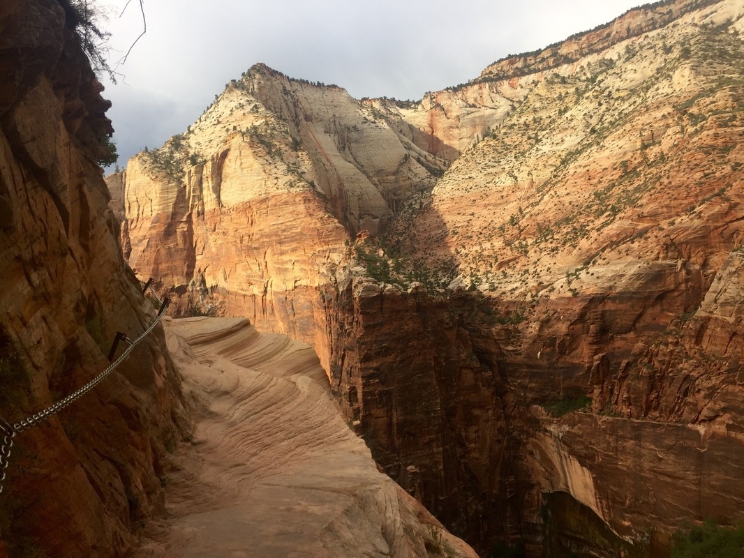
This epic trail is one of the top two attractions in Zion National Park. The fact the National Park Service even built this trail is remarkable. The path winds its way up steep switchbacks, through the coolness of Refrigerator Canyon, and past the strange geologic formation, “Walter’s Wiggles.” Once the trail gains the ridge-line, it continues to narrow and steepen as the ridge ascends 1500-feet above the valley floor below. After many false summits, the trail ends at an incredible perch, a bald, rocky prow, with 360-degree views of Zion Canyon. If you are extremely afraid of heights, you may not want to proceed past Scout’s Lookout, a natural viewpoint just before the ridge traverse. Many dealing with acrophobia and families with small kids stop at this viewpoint for great views without the exposure of the final portion of the hike.
LOGISTICS
Trailhead: Exit shuttle at the Grotto and follow the West Rim Trail.
Mileage: 5 miles (8 km), round-trip
Elevation Gain: 1520 feet (463 meters)
Approximate Hike Time: 4 hours, round-trip
Difficulty: Strenuous
Crowds: Common. However, the throng thins out as only the boldest hikers continue past Scout’s Lookout to the top.
WHEN TO GO
Best Times of Day: In the summer, early morning (5 - 8 a.m.) or late afternoon (6 - 9 p.m.) hiking avoids the crowds and heat of mid-day.
Best Times of Year: The comfortable temperatures, reliable weather, and dazzling foliage of autumn make it the best time to hike Angel’s Landing. The upper reaches of the hike can become quite icy January through March.
Update: You must apply HERE for a permit to hike Angel's Landing via the Zion National Park website beginning Jan. 3rd, 2022.
This epic trail is one of the top two attractions in Zion National Park. The fact the National Park Service even built this trail is remarkable. The path winds its way up steep switchbacks, through the coolness of Refrigerator Canyon, and past the strange geologic formation, “Walter’s Wiggles.” Once the trail gains the ridge-line, it continues to narrow and steepen as the ridge ascends 1500-feet above the valley floor below. After many false summits, the trail ends at an incredible perch, a bald, rocky prow, with 360-degree views of Zion Canyon. If you are extremely afraid of heights, you may not want to proceed past Scout’s Lookout, a natural viewpoint just before the ridge traverse. Many dealing with acrophobia and families with small kids stop at this viewpoint for great views without the exposure of the final portion of the hike.
LOGISTICS
Trailhead: Exit shuttle at the Grotto and follow the West Rim Trail.
Mileage: 5 miles (8 km), round-trip
Elevation Gain: 1520 feet (463 meters)
Approximate Hike Time: 4 hours, round-trip
Difficulty: Strenuous
Crowds: Common. However, the throng thins out as only the boldest hikers continue past Scout’s Lookout to the top.
WHEN TO GO
Best Times of Day: In the summer, early morning (5 - 8 a.m.) or late afternoon (6 - 9 p.m.) hiking avoids the crowds and heat of mid-day.
Best Times of Year: The comfortable temperatures, reliable weather, and dazzling foliage of autumn make it the best time to hike Angel’s Landing. The upper reaches of the hike can become quite icy January through March.
Emerald Pools
OVERVIEW
Located directly across from Zion Lodge, Emerald Pools might be the most-hiked trail in all of Zion. Featuring mild hiking, three optional loops, and elegant waterfalls, the Emerald Pools trail sees many visitors each day. On this walk, you can skirt behind thin veils of water, rock-hop across quiet streams, and gaze from a wide balcony onto perfect views of Mountain of the Sun. Ironically, the one thing you probably shouldn't expect, however, are any "emerald" pools... if the pools ever were shimmery and green, they are more clear and clean than bright emerald today.
LOGISTICS
Trailhead: Exit free Scenic Drive shuttle at Zion Lodge.
Mileage & Elevation:
• Lower Pool – 1.2 miles (1.9 km)/ 69 feet (21 meters), round-trip
• Middle Pool – 2 miles (3.2 km)/ 150 feet (46 meters), round-trip Currently inaccessible due to trail construction
• Upper Pool – 3 miles (4.8 km)/ 400 feet (119 meters), round-trip
Approximate Hike Time:
• Lower Pool – 1 hour, round-trip
• Middle Pool – 1.5 hours, round-trip
• Upper Pool – 2 hours, round-trip
Difficulty: Easy to moderate, depending on how far you go
Crowds: Heavy traffic is common, as Emerald Pools is one of the most popular hikes in the Park.
WHEN TO GO
Anytime!
Hidden Canyon Currently Closed for the Foreseeable Future
|
OVERVIEW
Hidden Canyon shares the Weeping Rock trailhead with the Weeping Rock and Observation Point trails, but is unique from them both. Hidden Canyon begins with the long, steep switchbacks of Observation Point, but after one half-mile, the Hidden Canyon trail leaves the pavement and turns into dirt. From this point, the trail intrigues hikers along cliff edges with chains and ledges, similar to Angels Landing. The last 1/8 mile (.2 km) is not difficult, ending at the mouth of Hidden Canyon. Exploring up-canyon reveals some hidden gems; one is a beautiful arch at the floor of the canyon. You can hike about 1.75 miles (2.8 km) up through the drainage, solving boulder obstacles along the way to reach each progressing level. Please make sure as you ascent the canyon that you will feel comfortable descending the sometimes imposing drops on the way back! |
|
LOGISTICS
Trailhead: Exit the free Scenic Drive shuttle at Weeping Rock trailhead and follow the trail to Observation Point, the East Rim, and Hidden Canyon.
Mileage: 2 miles (3.2 km), round-trip, or longer, depending on your perseverance
Elevation Gain: 850 feet (259 meters)
Approximate Hike Time: 3 hours, round-trip
Difficulty: Moderate, with strenuous sections
Crowds: Traffic thins out significantly when the trail splits off from the Observation Point/East Rim trail. The further into Hidden Canyon you delve, the fewer hikers you encounter.
WHEN TO GO
Anytime!
Observation Point - Accessible via the East Mesa Trailhead only
OVERVIEW
Avid hikers lavish in the diversity of this amazing trail. From the steep switchbacks taunting you along the first mile, to the serene beauty of Echo Canyon, to the breathtaking overlook at the summit, this trail pays dividends equal to the effort it requires. As you climb to Observation Point, you can imagine the efforts of the Civilian Conservation Corps, the group of workers who constructed this trail in the 1930s. Using dynamite, wheelbarrows, and mules, these young men blasted this pathway up the walls of Zion Canyon, connecting Zion’s East Side with the main valley floor. Echo Canyon, a serpentine water-carved slot is revealed within the first hour of hiking. After passing the East Mesa trail junction, the trail winds along a red stained pathway, where the soft Temple Cap rock has eroded to meet the harder Navajo Sandstone layer. The juniper and pinyon pine forested summit peers into Zion Canyon from 6507 feet (1983 meters).
LOGISTICS
Trailhead: Exit free Scenic Drive shuttle at Weeping Rock trailhead and follow the trail to Observation Point, the East Rim, and Hidden Canyon.
Mileage: 8 miles (12.9km), round-trip
Elevation Gain: 2150feet (655 meters)
Approximate Hike Time: 6 hours, round-trip
Difficulty: Strenuous
Crowds: Crowds steadily dwindle the farther you ascend. Only a handful of parties push to the summit each day.
WHEN TO GO
The upper reaches of the hike can become icy and/or snow-packed December through March; inquire about conditions at the Visitor’s Center before making a winter ascent.
Pa 'Rus Trail
|
OVERVIEW This is the easiest trail in the Park, and the only one which allows leashed dogs and/or bikes. The Pa’ Rus meanders north from South Campground, following the Virgin River up the wide valley of southern Zion Canyon. This is a perfect trail for after-dinner strolls, surrounding you with grand towers cast in brilliant oranges, browns, and reds by the evening alpenglow. Wildlife is also common along this trail, as deer, coyotes, foxes, and even mountain lions visit the river for water early and late in the day. |
|
LOGISTICS
Trailhead: No shuttle necessary. Park just before the south Entrance Station OR at the Visitor’s Center and walk to the South Campground, where the trail begins.
Mileage: 3.5 miles (5.6 km), round-trip, out-and-back
Elevation Gain: Very little change
Approximate Hike Time: 1. 5 hours, round-trip
Difficulty: Very easy
Crowds: Minimal. Beware of speeding bicyclists!
WHEN TO GO
Spring brings untold blossoms to the Pa’ Rus trail, as well as the re-emergence of a wide variety of valley wildlife. The Pa' Rus is particularly beautiful in early November, when the cottonwoods lining the river turn golden.
Riverside Walk
OVERVIEW
The Riverside Walk is the gateway to the Zion Narrows. From the moment you leave the parking lot, you are quietly drawn into the mystery of the narrowing, looming walls. Ultimately, you must choose whether to enter the water at pavement’s end, or turn back wondering. There is something emotional about following the walkway to its end and witnessing the river disappear from your view.
LOGISTICS
Trailhead: Exit free Scenic Drive shuttle at Temple of Sinawava trailhead, the terminal stop on the Scenice Drive.
Mileage: 2 miles (3.2 km), round-trip
Elevation Gain: 57 feet (17 meters)
Approximate Hike Time: 1 hour, round-trip
Difficulty: Casual
Crowds: Common. Many people hike up hoping for a glimpse of the Narrows. Those who are prepared continue on up the river, leaving the gawking crowds behind.
WHEN TO GO
Anytime. Ice on trail may cause closure of this trail during winter months.
Sand Bench Trail
OVERVIEW
Are you looking for a short jaunt along the river, a morning run to warm up your quads for Angels Landing, or a light hike in afternoon shade? This subtle, beautiful loop trail matches all these descriptions well. Scrambling along river’s edge and meandering through low foothills, Sand Bench wanders along the base of the Patriarchs, Jacob, Abraham, and Isaac, on the west side of the Virgin River. East of the river, the trail is flat and sandy, offering easy hiking and great river vistas. The Sand Bench is a great hike for kids, or those wanting a tasty, rather than torturous, hike.
LOGISTICS
Trailhead: Exit free Scenic Drive shuttle at the Zion Lodge or Court of the Patriarchs trailhead. If you start at the Court of Patriarchs, walk across the Canyon Drive to a service road, then across the bridge to the connecting trail system.
Mileage: 3.6 miles (5.8 km), round-trip
Elevation Gain: 500 feet (152 meters), round-trip
Approximate Hike Time: 3 hours, round-trip
Difficulty: Moderately easy
Crowds: You’ll find few hikers on this trail, but many four-legged friends and their droppings. Horse tours follow this trail every day, March through October, from 7 a.m. to 5 p.m. Inquire at Zion Lodge for this alternative and sought-after form of exploration.
WHEN TO GO
Best Times of Day: Hike before 7am or after 5pm to avoid the equine caravans, March thru October.
Best Times of Year: Hike the Sand Bench November thru February for a horse-free trail and riverside tranquility.
Watchman Trail
OVERVIEW
The Watchman Trail takes you out of the grassy main valley and skirts alongside the cliff sides of an intimate side canyon. After a length of short switchbacks, the trail traverses a long slope and crosses a perennial spring, up to a panoramic viewpoint. Enjoy the view from the top, or explore down thin dirt trails to the cliff edges. The grand Watchman formation overlooks the final viewpoint, giving the trail its name.
LOGISTICS
Trailhead: No shuttle necessary. The trail begins on the service road just east of the Visitor’s Center.
Mileage: 3.5 miles (5.6 km), round-trip
Elevation Gain: 368 feet (112 m)
Approximate Hike Time: 2 hours, round-trip
Difficulty: Moderate
Crowds: This trail sees moderate traffic.
WHEN TO GO
Best Times of Day: Before 9 a.m., Watchman hikers enjoy shade year-round; the rest of the day, however, can be very hot. The Watchman Trail’s proximity to Springdale and the campgrounds also make it a favorite for after-dinner evening strolls.
Best Times of Year: Any season is a good one here. The Watchman is a favorite winter hike, as it stays fairly warm and snow-free.
Weeping Rock Currently Closed for the Foreseeable Future
OVERVIEW
Weeping Rock is an overhanging blind arch which “rains” every day of the year. The spring water seeping out of the rock 100 feet overhead takes nearly 1000 years to travel through the porous Navajo sandstone above. The percolation slows at the underlying dense, less porous Kayenta sandstone layer, then follows a downhill course, raining on the observers below. Weeping Rock’s charm sometimes draws visitors to sit beneath its cascade of raindrops for hours.
LOGISTICS
Trailhead: Exit the free Scenic Drive shuttle at Weeping Rock trailhead.
Mileage: .5 miles (.8 km)
Elevation Gain: 98 feet (30 meters)
Approximate Hike Time: 30 minutes, round-trip
Difficulty: Easy
Crowds: Easy access, short distance, and dramatic views make this one of the most crowded hikes in the Park.
WHEN TO GO
Best Times of Day: Hike Weeping Rock trail early in the morning for a chance to sit and listen to the falling water in solitude.
Best Times of Year: When the spring wildflowers bloom, the moist environment along this trail is abundant with color. Summer storms produce dazzling waterfalls all around Weeping Rock.
About Us
|
Adventure Blog
|
Open Daily
March - October, 8am-8pm November, 8am-7pm December - February 9am-5pm *Closed on Thanksgiving and Christmas |

|
36 Lion Blvd. Springdale, UT 84767 Springdale Shuttle Stop 3 |

|

|
|