THE ZION NARROWS
|
Many visitors to Zion National Park wait months, if not years, to finally get the opportunity to explore the Narrows. Once they've planned the vacation or secured the permits, many wonder, "What now?" Don't worry, we have got you covered.
Zion Adventures™ has spent over 25 years perfecting the outfitting process to help deliver the best Narrows experience possible. As Zion's first adventure company, we've been on the innovative forefront of all things outfitting since day one. The following pages and orientation video are designed as a detailed resource for route planning, identifying the appropriate gear for your specific hike, obtaining permits, and reserving a trail head shuttle through Zion Adventures™. While we do our best to reflect average seasonal conditions in the Narrows, we strongly recommend checking weather conditions periodically in the days and hours leading up to your hike. |
|
Options FOR THE NARROWS
Bottom-Up Day Hike
Most visitors choose this route because the hike can be just a couple of hours or all day. Just 2 miles upstream Orderville Canyon enters on the right. This is a favorite side trip for many because of the trickling water and narrower walls. Quite frankly, it’s so pretty in there.
During summer months, the beginning of the trail can be crowded with others who want to enjoy the experience as much as you. For a quieter exploration, plan to start early. For early risers, rent a couple of E-Bikes or hybrid trail bikes and head up at your leisure. With the trailhead parking lot filling up before 6:30 am, we offer the convenience of an express Narrows Shuttle. For $40, we'll take you up, drop you off, and pick you up..
Difficulty: Moderate.
Mileage: 2 - 10 miles / 3 - 16 km round trip.
Trailhead: Start at the Temple of Sinawava, hike the Riverside Walk and enter the Virgin River.
Note: The National Park Service allows you to hike 4 miles up stream-to Big Springs- before requiring you turn around.
Top-Down Day Hike
Starting at Chamberlain's Ranch, the Top-Down Narrows hike is 16 miles to the Temple of Sinawava. You can do this in one day or two.
Traveling the entire length of the Narrows in one day requires a somewhat driven approach. It typically takes about 10 – 12 hours of continuous hiking and in order to enjoy the experience, you’ve got to like that kind of day.
Difficulty: Strenuous.
Mileage & Duration: 16 miles / 26 km; averaging 10 - 12 hours of continuous hiking.
Trailhead: Chamberlain's Ranch.
Note: A Zion National Park Wilderness permit is required and if the Virgin River is flowing at 120 CFS (cubic feet per second) or more, no permits are issued. Only 40 permits are given each day. Reservations are recommended.
|
|
Top-Down Overnight
A backpacking trip allows you more time to enjoy the Narrows at a leisurely pace, and spending the night between the canyon walls is magical. There are 12 numbered campsites over the course of a two mile stretch of canyon.
Difficulty: Moderate
Duration & Mileage: 16 miles / 26 km
Trailhead: Chamberlain's Ranch.
Note: A Zion National Park Wilderness permit is required and if the Virgin River is flowing at 120 CFS (cubic feet per second) or more, no permits are issued. Only 40 permits are given each day. In addition, only 12 campsites are available and just two of those can accommodate groups of more than 6 people, so reservations are recommended.
|
Call 435.772.1001 to Reserve Shuttle |
|
Click on the map to download a pdf version.
|
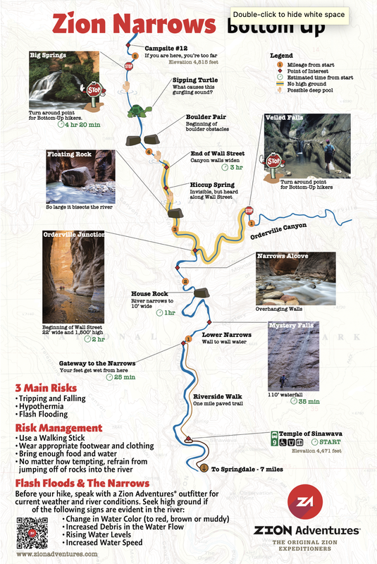
Narrows Bottom Up Map PDF
|
Frequently asked questions about hiking the zion Narrows
What about the Cyanobacteria and River Warnings?
The Southwest Utah Public Health Department has down-graded their Warning to a Health Watch for the North Fork of the Virgin River. During the summer of 2020, because the conditions were just so, blue green algae was evident in parts of the Virgin River. It occurred in such levels that the Park issued warnings about swimming and ingesting the water.
https://deq.utah.gov/water-quality/north-fork-of-the-virgin-river-algal-bloom-monitoring-2020
Cyanobacteria is a natural occurrence, but when in abundance can affect the health of people, animals and other organisms if ingested. The health department recommends that you refrain from drinking, swimming or submerging your head underwater so that you don't accidentally ingest river water at this time. Many are hiking, but it's best to be careful:
How long is the bottom up day hike?
The Narrows starts at the Temple of Sinawava. The first mile is paved and takes about 30 minutes. The next two miles -at a wandering pace- takes 2 hours. From here, you can hike another 2 miles into the Narrows proper and/or take a side trip into Orderville Canyon - a more narrow canyon that enters on the right.
Your return hike will take about a 1/2 hour less than the time it took to hike up. Most people are happy with a 5 hour - 6 1/2 hour hike.
How deep is the water?
On your way to the confluence of Orderville, the water will be ankle-deep to waist-deep depending on your route-finding. Summer 2023 saw an increase in rain and fluctuating river flow. There is currently a deep hole in the beginning of the bottom-up hike that has not previously existed. It will fill with sediment at some point, but it looks like it will remain through the winter. Once you enter the Narrows proper, it gets deeper until you are swimming through a short section.
What should I bring?
A liter or 2 of water
Plenty of food/snacks - more than you'd take on a regular hike
Extra layers - like fleece, gloves and a hat - for warmth
Waterproof bag for your phone, camera & food
Do I need to take a shuttle?
Most times, yes.The free National Park shuttles are running from the Zion National Park Visitor Center. Depending on the day and time, there may be no wait, a short wait, or upwards of 2 hours. It's difficult to predict. During the winter months, with the exception of holidays, you can drive your car to the Temple of Sinawava. Around the holidays, you will need to take the park shuttle.
To avoid the crowded shuttles, rent bicycles or e-bikes and ride the 7 1/2 miles to the trailhead. E-bikes make it easy.
If I make a reservation, where can I park my car?
Unfortunately, Springdale does not offer free parking.
1. Park on Lion Blvd in front of Zion Adventures™. It's $12/day and you pay at the on-street kiosks.
2. Park in the dirt lot next to us. This privately owned lot is $20/day and they only take cash. You'll fill out the envelope and insert it in the box.
3. Leave your vehicle at your hotel and take the free Springdale Town Shuttle to Stop #3.
The Southwest Utah Public Health Department has down-graded their Warning to a Health Watch for the North Fork of the Virgin River. During the summer of 2020, because the conditions were just so, blue green algae was evident in parts of the Virgin River. It occurred in such levels that the Park issued warnings about swimming and ingesting the water.
https://deq.utah.gov/water-quality/north-fork-of-the-virgin-river-algal-bloom-monitoring-2020
Cyanobacteria is a natural occurrence, but when in abundance can affect the health of people, animals and other organisms if ingested. The health department recommends that you refrain from drinking, swimming or submerging your head underwater so that you don't accidentally ingest river water at this time. Many are hiking, but it's best to be careful:
- Do not submerge your head under water
- Do not drink river water. Toxins cannot be filtered out by ordinary backpacking filtration systems.
- The highest risk is to young children who may slip and accidentally ingest some of the water. If you are concerned your child may not be able to take proper precautions, you may want to plan your trip for another time.
- Canyoneering and hiking is allowed.
How long is the bottom up day hike?
The Narrows starts at the Temple of Sinawava. The first mile is paved and takes about 30 minutes. The next two miles -at a wandering pace- takes 2 hours. From here, you can hike another 2 miles into the Narrows proper and/or take a side trip into Orderville Canyon - a more narrow canyon that enters on the right.
Your return hike will take about a 1/2 hour less than the time it took to hike up. Most people are happy with a 5 hour - 6 1/2 hour hike.
How deep is the water?
On your way to the confluence of Orderville, the water will be ankle-deep to waist-deep depending on your route-finding. Summer 2023 saw an increase in rain and fluctuating river flow. There is currently a deep hole in the beginning of the bottom-up hike that has not previously existed. It will fill with sediment at some point, but it looks like it will remain through the winter. Once you enter the Narrows proper, it gets deeper until you are swimming through a short section.
What should I bring?
A liter or 2 of water
Plenty of food/snacks - more than you'd take on a regular hike
Extra layers - like fleece, gloves and a hat - for warmth
Waterproof bag for your phone, camera & food
Do I need to take a shuttle?
Most times, yes.The free National Park shuttles are running from the Zion National Park Visitor Center. Depending on the day and time, there may be no wait, a short wait, or upwards of 2 hours. It's difficult to predict. During the winter months, with the exception of holidays, you can drive your car to the Temple of Sinawava. Around the holidays, you will need to take the park shuttle.
To avoid the crowded shuttles, rent bicycles or e-bikes and ride the 7 1/2 miles to the trailhead. E-bikes make it easy.
If I make a reservation, where can I park my car?
Unfortunately, Springdale does not offer free parking.
1. Park on Lion Blvd in front of Zion Adventures™. It's $12/day and you pay at the on-street kiosks.
2. Park in the dirt lot next to us. This privately owned lot is $20/day and they only take cash. You'll fill out the envelope and insert it in the box.
3. Leave your vehicle at your hotel and take the free Springdale Town Shuttle to Stop #3.


About Us
|
Adventure Blog
|
Open Daily
March - October, 8am-8pm November, 8am-7pm December - February 9am-5pm *Closed on Thanksgiving and Christmas |

|
36 Lion Blvd. Springdale, UT 84767 Springdale Shuttle Stop 3 |

|

|
|